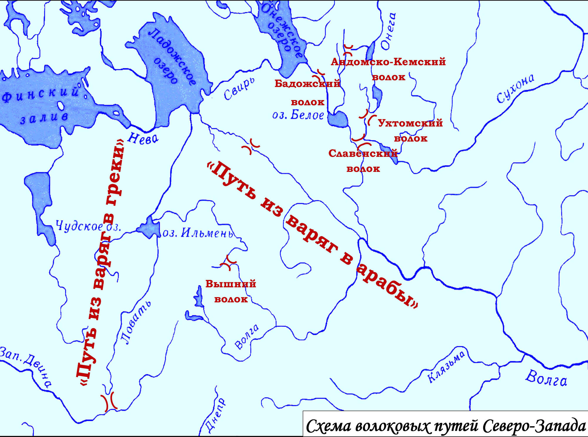
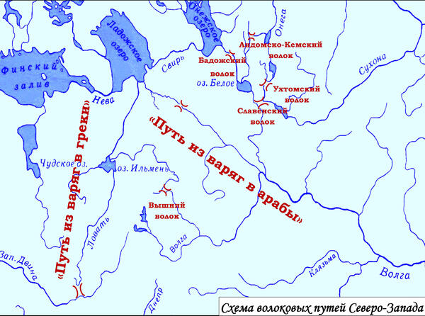
For a medieval traveler, the territory of the Russian North was difficult to traverse, and often impassable altogether, with forests and swamps. Overland roads were only introduced in the 16th century, but it was more convenient and quicker to sail on water or to use sleds on winter roads than to travel on horseback or on wheeled transport. Several important waterways passed through the BEloye Ozero in the Middle Ages and later.
The waterway from Beloye Ozero to Lake Onega and onwards to Lake Ladoga, which is similar to the modern route of the Volga-Baltic Way, according to archaeological records, existed already in the 10th century. The discoverers of this path were probably Novgorodians, who advanced along the VYtegra to the lower reaches of KEma. This path was also known to the Scandinavians, as the findings of the Scandinavian objects on the Kem river, the tributary of the KOvzha river, attest.
The second most important waterway through the BEloye Ozero was the route to the Volga. It is the only northern water artery, the movement via which is attested in the ‘Tale of Bygone Years’. It is mentioned in a 1071 chronicle article about the procession of the Magi during a crop failure in the Rostov-Suzdal Land. The ShEksna river route was known since the earliest times, long before the arrival of the Slavs on the Upper Volga. No later than the second half of the 9th century, it had already formed part of The Great Volga River Route, which connected the countries of the Caliphate with Scandinavia, and had its hey-day in the 9th and 10th centuries. At the end of the 10th century, the Volga Route ceased to be a conduit for international trade, but movement on Shakesna continued. Shakesna continued to serve as a bridge between the North and the central districts of Russia.
The Beloye Ozero was also a transit route for the waterways to the North and the North-East – to the Onega river, SukhOna river and North DvIna river. The way to the head reaches of OnEga was through UhtOma, which flows into the Beloye Ozero, to Volotskoye Ozero, and further along the logway (‘volok’) into Long Lake, from which flows another Uhtoma, the tributary of Modlona.
In the Russian language ‘volok’ comes from the word ‘to drag along’. In the old times the water craft would be dragged on logs along the land parts of the route between rivers and lakes. The cadaster of 1585 mentions the ‘old logway’ (also known as the ‘red logway’) between the two Uhtoma rivers - BElozerskaya and VOzheozerskaya. According to archaeological excavations, this route was created no later than the beginning of the 11th century.
The first mention of Slavensky Logway dates back to 1389. According to archaeological research, it was created in the early 11th century by Belozersk inhabitants, whose graves were discovered in the burial ground of NephEdyevo. Western European coins, glass beads and other imports were imported eastwards through the Slavensky Logway.